return to Home page

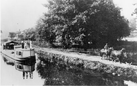
The Wharf on Merwin Street

 
From the 1825 opening of the Erie Canal in New York to the 1850s when railroads connected the east coast to northeast Ohio, most European immigrants arrived here by boat. The wharf on Merwin Street is a good place to remember them.

Our region's first settlers and many who came later were Americans from Connecticut and other New England states, New York and Pennsylvania. In these early years our region was our nation's Northwest, with its natural resources, cheaper land and chances to make (or to increase) one's fortune. These Americans loaded their belongings in horse-drawn wagons and traveled on primitive roads west to northeast Ohio.

Starting in the 1830s political unrest and economic hardship across the Atlantic and the faster, more reliable ocean travel that steamships provided, brought immigrants here from other lands. They came with only what they could carry and they came by boat.

The story of one journey to Cleveland:

They came here because they had a local connection,  a friend or relative named Simson Thorman. Knowing they faced a long difficult journey and hard years in a new land, they traveled as a group with few young children. They left their parents behind, hoping to bring them over later. They came in the summer, for the warmer and longer days.

Horse-drawn coaches took them from their village to a river, where river-by-river, on boats with coaches used to make some connections, they arrived at a port on the Atlantic. A schooner took them across the ocean to New York City, then a boat up the Hudson River to Albany and the Erie Canal to Buffalo. The last leg of their trip was on a steamer that docked near the mouth of the Cuyahoga. Their journey took nearly three months.

This was the story of a group from Unsleben Bavaria that left its village on May 5, 1839 and whose arrival in early August marks the start of Cleveland's Jewish community. It is also the broad outline of the tale of thousands of other immigrants from central Europe, Ireland, Scotland, England, Wales and elsewhere.

Some immigrants came by a southern route in those pre-railroad days. Arriving at a port on the east coast they traveled to the Ohio River, possibly at Pittsburgh, then west by steamboat to the most southern point of the Ohio - Erie Canal and north on a small canal boat.

Merwin's Wharf, though not where those immigrants first set foot in northern Ohio, is a place to celebrate their arrival.


Boat pulling a barge on the Ohio - Erie Canal in 1902

The Ontario, the first steamboat to operate on the Great Lakes

The Ohio and Erie Canal was constructed during the 1820s and early 1830s in Ohio. It connected Akron with the Cuyahoga River near its outlet on Lake Erie in Cleveland, and a few years later, with the Ohio River near Portsmouth. It also had connections to other canal systems in Pennsylvania. See Wikipedia.

Canal boats and barges had little draft and were low so they could pass under bridges across the canal.

The "steamers" were steam engine powered boats with  side-mounted paddle wheels. Designed for travel on the lake, they could not navigate the shallow and winding Cuyahoga River and their masts and smoke stacks would not clear the many bridges across the river.

In the late 1820s wooden piers built on Lake Erie near the mouth of the river welcomed steamers, which by 1840 might be 300 feet long.


Then why is Merwin's Wharf a place to remember those early immigrants? It does lie near the northern end of the Ohio-Erie Canal and not far south of the wooden pier on Lake Erie near the mouth of the river: the places where immigrants of those pre-railroad day would have landed.

With a clear view of the river and the trees on the west bank, it may be like the view of those years long ago. It is also a quiet place to reflect on those years. Those whose ancestors came here by water, can give thanks for their courage to leave their homes to find freedom and better lives for themselves and their descendants.

At the right is what an Ohio Historical Marker erected on Cleveland Metroparks property on the river bank might say.

A WELCOMING PLACE  1825 -1855

In the years after the construction of the Erie Canal in New York and the Ohio and Erie Canal in Ohio, and before railroad lines reached Cleveland, many from other lands came to northeast Ohio by water.

Most arrived on steamboats that docked north of this point, near where the river meets the lake. Some came by boat on the Ohio River, then north on the canal.

They helped build this city and this region.


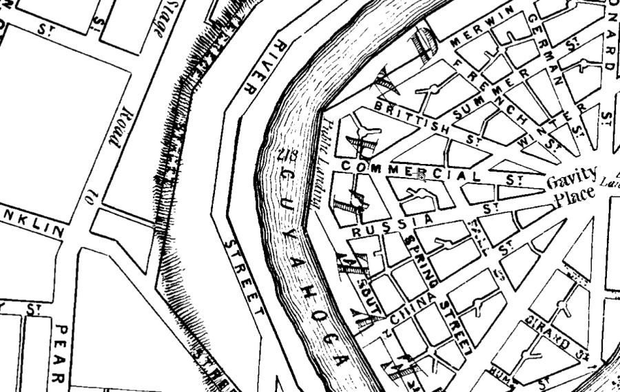
An 1835 map showing the wharf

Surveyor Ahaz Merchant (1794-1862) prepared this map in 1835  There are steep hills on both sides of the river valley. Merchant's map show them as close short lines. 

Here at Irishtown Bend on the west side the hill is very close to the river. When this map was drawn the land west of the river was in Brooklyn Township, but in 1836 it became Ohio City

The land in the peninsula bounded on three sides by the Cuyahoga River was owned by real estate speculators who called it Cleveland Centre and gave the streets names that envisioned it as a center of international trade, and its center was named Gravity Place.

At the foot of Commercial Street and the start of Merwin Street we see the wharf as Public Landing.
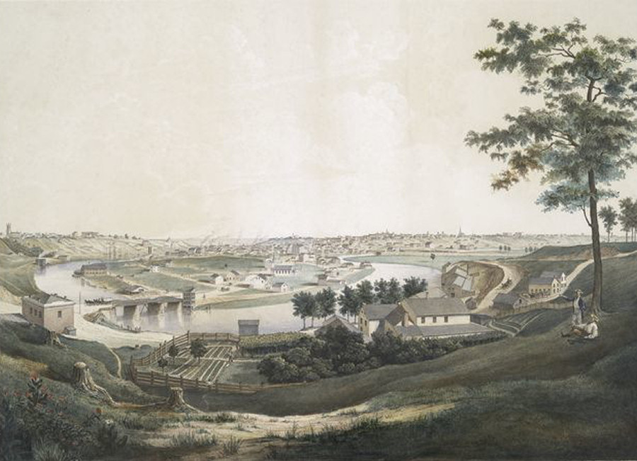
 

Oxbow Bend in 1851

To early settlers the peninsula that the Cuyahoga River forms here as it makes its snake-like way to Lake Erie was like the "U" shaped metal bow that held an ox to its yoke. Thus the name "Oxbow Bend". Cleveland Centre" (the peninsula) and Ohio City, at the left past the river, are now in the city. At the left of this drawing of the view north, toward the lake, we see the Columbus Street Bridge (1835). once a place of great controversy.

North of the bridge, along the river's east bank, is the public landing — the wharf on Merwin Street.

About this image
"Panorama of Cleveland and Ohio City, taken from Scranton Heights"  This image, scanned from a book "History of Cleveland" by James Harrison Kennedy. 1896, was found in the Cleveland Memory Project.

It is also online in a New York Public Library print collection in color, dated 1851 and attributed to artist Jacob Mueller and lithographer Otto Onken. View the  print on the NYPL website


The area in 1858 and now - transformed again and again

In 1858, the year of the map shown below left, Cleveland's population was about 40,000 — nearly seven times what Merchant noted on his 1835 map.

A major reason was voters of adjacent towns and villages asking to join Cleveland, which would then annex them. A prime example: Ohio City in 1854.

Railroads had reached Cleveland. One line can be seen below. Later maps show many more.

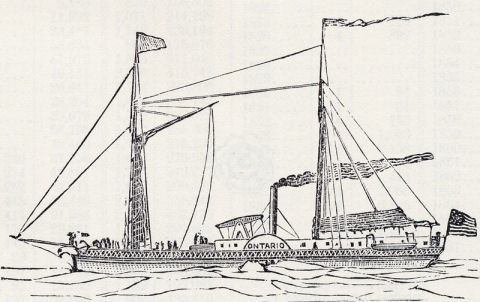
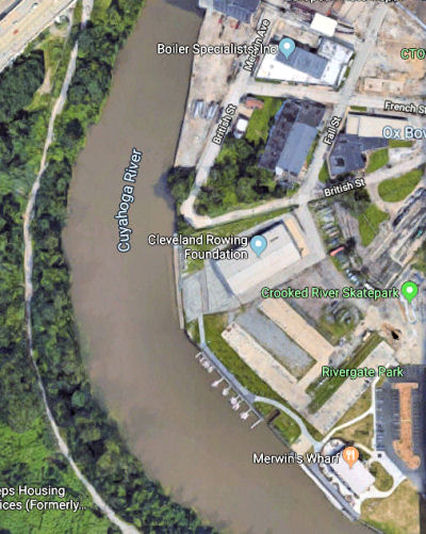
The public landing on Merwin Street is gone. The hundreds of steam ships that came each year could now land at a pier on the shore of Lake Erie.

The recent Google satellite view (below right) shows a river widened on its west bank and its hillside built up and planted. Merwin's Wharf, the Cleveland Metroparks restaurant, can be seen in the lower right. The actual site of the old wharf is about 300 yards north, on the east bank, near the top of the image below.


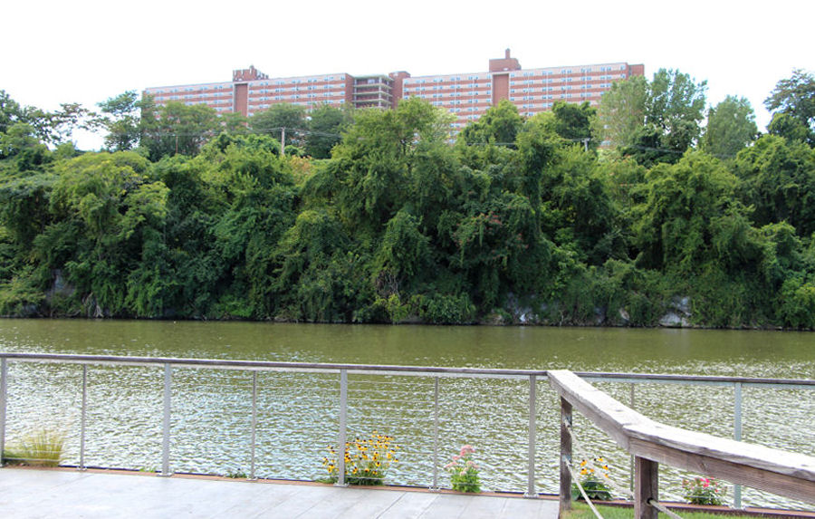
The west bank of the Cuyahoga River as seen from the wharf

The Cuyahoga River here, at what is called Irishtown Bend, has an unusual feature: a bluff on its west side that rises about 120 feet higher than the east bank and overlooks downtown Cleveland. On it is Riverview Terrace, a 600 foot long 15 story building  built in 1963. It offers 490 apartments for seniors. The far side of the building faces West 25th Street. Even without this building, the site is very different from what those landing at the wharf on Merwin Street would have seen. The river has been widened to allow ore ships to navigate safely, the hill has been built up and planted, and bulkheads driven into the river bed positioned to keep the hill from sliding into the river and restricting river traffic.

  Photo by Robert N. Brown

Thanks to Judy MacKeigan, Historian/Archivist, Cleveland Metroparks and Martin Hauserman and Charles Mocsiran of the Cleveland City Council Archives
 

Learn more   (these external links will open in a new window)

9/23/19

Top of Page              CJH Home